

What is a Watershed?
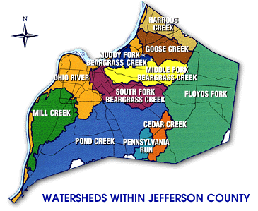
A watershed is the area of land where all water running off the land drains to a particular location. This location can be a stream, river, lake, wetland or ocean. No matter where you live, work, or play, you are in a watershed. A watershed can be millions of square miles (like the watershed for the Mississippi River) to a few acres (like the watershed of a farm pond). The eleven major watersheds in Jefferson County all eventually drain to the Ohio River. The major Jefferson County watersheds are:
- Cedar Creek
- Floyds Fork
- Goose Creek
- Harrods Creek
- Middle Fork of Beargrass Creek
- Mill Creek
- Muddy Fork of Beargrass Creek
- Ohio River
- Pennsylvania Run
- Pond Creek
- South Fork of Beargrass Creek
What is Watershed Management?
Watershed Management is a holistic approach to managing the combined impacts to the water resources and habitat within a watershed. Examples of these impacts are land use practices, erosion, wastewater treatment systems, stormwater collection systems, and pesticide uses. There are four major features unique to watershed management. The features are:
- Create an inventory of the watershed and target priority problems.
- Involve a maximum amount of stakeholders in decision making.
- Use the expertise and authority of the regulatory agencies.
- Measure the success thorough monitoring and other data collection.